Some US county recorders of deeds in states that are federal land states have tract, lot, or parcel indexes to land records that index land deeds based upon where the property is located. For rural areas these indexes usually are as specific as the quartersection. In towns they usually are for the specific lot. There can be exceptions. These indexes require the precise location of the property be known. They can be helpful finding transactions that slip through other indexes or don’t include all family names.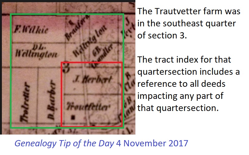
The deeds for the Trautvetter family in the illustration will be indexed in two different sections of the tract index:
- some will be in the southeast quarter of section 3
- others will be in the southwest quarter of section 3


8 Responses
It frustrates me that there is no app or other way to discern what plot coordinates (Township, range, section) from an old county map would translate to address-wise on a contemporary map. I have the land deeds from many ancestors, am able to locate them on an old map, but only on an old map. And, that’s only IF I can find an old map of the county or township that shows those divisions. It seems like that shouldn’t be such a complicated thing, but I’ve not found any way to it other than guesstimate by painstakingly refer back and forth to an old map with the info to a new one, and try to figure it out by gauging distances from towns, county lines, and other landmarks such as rivers.
Are these in state land states or federal land states? In federal land states locating the property today shouldn’t be a difficulty.
I agree. I’ve only been able to identify 1 plot of family land on a current map. And that’s only because it has a pond on it that still has the same name.
In what state is this, Kristin?
Anne,
Are these in state land states or federal land states? If they are federal land states, it shouldn’t be that hard.
You start with your old map and note what township, range and section the land is in. Get a current map and find that same township, range and section.
What I find is that if I am looking at more than 100 years ago, people had larger farms, so the land may be divided up in today’s world, but again, it’s still the same township, range and section number.
Brenda
My state (Mississippi) has county maps showing township, range and sections. Before the internet, I purchased these maps from the highway department for the counties of interest. I also purchased county maps from other states.
Mississippi now has the maps on the internet at the highway department web site. These maps are invaluable for research! Also, before going on little jaunts in the countryside, I often print out maps before leaving home — just so we know where we are going!
Thanks, Kat. It’s always good to have print maps. Those maps are good for making cemetery jaunts as well.
After posting my comment about county highway maps, I looked for them in several states, finding it better to go to the “Department of Transportation” to look for the online maps showing township, range & section. I’m not sure if all states have these maps available on line.