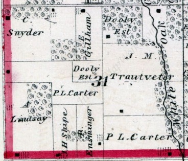
An 1874 plat book shows where the J. M. Trautvetter farm was located in section 31 of Walker Township, Hancock County, Illinois. I need to remember when looking at any land ownership maps that they may not be entirely and completely accurate.
These maps were compiled from local tax and land records and there is always the chance for an error to occasionally creep in. These books are not legal records, would not be considered proof of ownership, and (from the genealogist’s standpoint) should be used as a springboard to other records–particularly tax and property records to validate ownership.
These maps can help in locating nearby schools, churches, cemeteries, and towns, but they are not perfect. A parcel my father owned was shown incorrectly in the plat book for nearly twenty years until it was corrected. That plat book did not matter. What did matter was that he had a deed for the property than had been property recorded, there were no liens or mortgages on the property which would have impacted the title, and the taxes were always paid.
Survey plats of properties, created and recorded by authorized surveyors are legal records of property boundaries. But that’s different from commercially printed atlases and plat books.


No responses yet